A. GIS data types
GIS can be thought of as a system of hardware and software wherein geographically referenced data (spatial data) and associated attributes (non-spatial data) can be captured for manipulation, analysis, and modelling to assist and speed up decision making and management task (Joseph and Chockalingam, 2018). This definition mention two basic types of data used in GIS. Spatial data describes the absolute and relative location of geographic features. Whereas, attribute data describes characteristics of the spatial features. Here spatial data gives answers of where and attribute data tries to answer of what for a certain feature on the earth surface.
1. Spatial data
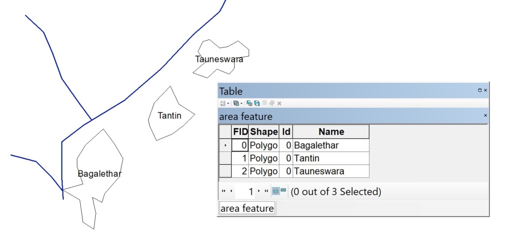
First is the spatial data which consists the location information. These can be point of a certain earth features, or a line representing linear features like road or river, polygons that reflects area covered by certain land use type, and surface features representing the elevation of surface. Such spatial data can be discrete or continuous depending upon the type of feature it is representing. Information of buildings and roads can be discrete while meteorological information like temperature, and rainfall represents continuous spatial data. These spatial data can be represented by vector and raster data formats. In the left side of following image there are certain polygons that represent area of villages that are adjacent to a river shown by linear features.
2. Attribute data
Second one is attribute data that explains the characteristics of certain geographical features. These characteristics can be quantitative and/or qualitative in nature. Attribute data is often referred to as tabular data. It is non-spatial data as it only consists of textual information that describes the geographic entity without revealing their information. Characteristics like height of building, length of roads, area of forests, and so on can be compiled as tabular format and expressed as attribute data. In above figure there is a table that represent attribute data as it consists information of id, shape, and name of spatial features. Further data regarding the area of each features, and other characteristics can also be added in this table.
B. Data Models
A model is the simplified representation of the real world phenomena or a system. The representation of a certain location in one’s mind can varies from others’ perspectives so it will create problems while such conceptual models are to be shared. To share models there should be some uniformity and in case of earth representation they should possess the capacity to be analysed. In this regard, the real world entity is digitally and logically represented as a data model that consists spatial information as well as attributes. Thus data models in GIS are geographic in nature so that they can be stored, retrieved, shared, and analysed whenever needed in order to solve the real world problems.
Vector, raster, and image are three data models. Vector and raster data models are encoded with location information to be used in analysis and modelling. Image or photograph is similar to raster data model but its format obstructs the capability of image to be analysed.
1. Vector data
Vector data are characterized by the use of points or coordinates to represent the geographical features where each points cane be connected to form lines or polygons. The points or vertices consists of x and y coordinate. In vector data model all geographic features are represented by polygon (area), line (or arc) and point.
- Point is represented by a 2 dimensional coordinate. Point data is most commonly used to represent nonadjacent features and to represent discrete data points. Points have zero dimensions, therefore you can measure neither length nor area with this dataset. In following figure star is a symbol representing Kakrebihar temple.
- Line (or arc) is a series of points connected by line vectors. The coordinate location is stored in each points. Minimum of 2 coordinates can form a line. Line data is used to represent linear features. Common examples would be rivers, trails, and streets. Line features only have one dimension and therefore can only be used to measure length. Line features have a starting and ending point. In the following figure red line represent the access road to the temple.
- Polygons are formed by series of points that are connected by line vectors to form a closed loop where beginning and ending point is same. The coordinate location is stored in each points. They are used to represent areas such as the boundary of a city (on a large scale map), lake, or forest. Polygon features are two dimensional and therefore can be used to measure the area and perimeter of a geographic feature. The green polygon is forest.

2. Raster Data
A raster data model is formed of regular grids of cells, organized into rows and columns where each cell contains certain information value. Raster data represents the fourth type of feature: surfaces. Raster data is cell-based and this data category also includes aerial and satellite imagery. The cells also called pixels of such imageries record the EMR coming from the ground surface and store as digital numbers (DN). The differences in DN value gives the peculiar appearance of ground features. Other characteristics of raster data that can influence appearance is the size of the cells. Larger cell size produce blocky appearances and when the cell size is decreased the features can have smooth look.
Raster data can be discrete or continuous. An example of discrete raster data is population density. Continuous data examples are temperature and elevation measurements. Following image represents the raster format of the Kakrebihar forest which are given by vector data model in above figure.

