Remote Sensing (RS) is the most prominent technique of collecting information from distance. So collected data are remotely sensed data. It is science of acquiring information about the earth’s surface without actually being in physical contact with the surface. There are various categories of remote sensing starting from observation by naked eyes, photography by camera, photography from aircraft, and sensing by sensors from space satellite.
Some definitions
- “Remote sensing is the science (and to some extent, art) of acquiring information about the Earth’s surface without actually being in contact with it. This is done by sensing and recording reflected or emitted energy and processing, analyzing, and applying that information. “
- The term “remote sensing” means the sensing of the Earth’s surface from space by making use of the properties of electromagnetic waves emitted, reflected or diffracted by the sensed objects, for the purpose of improving natural resources management, land use and the protection of the environment (UN, 1986).
Electromagnetic Spectrum
The first requirement for remote sensing is to have an energy source to illuminate the target (unless the sensed energy is being emitted by the target). This energy is in the form of electromagnetic radiation (EMR). All electromagnetic radiation has fundamental properties and behaves in predictable ways according to the basics of wave theory. Electromagnetic radiation consists of an electrical field (E) which varies in magnitude in a direction perpendicular to the direction in which the radiation is traveling, and a magnetic field (M) oriented at right angles to the electrical field. Both these fields travel at the speed of light (c).
Two characteristics of electromagnetic radiation are particularly important for understanding remote sensing. These are the wavelength and frequency and are reciprocal to each other in relation. The wavelength is the length of one wave cycle, which can be measured as the distance between successive wave crests. Frequency refers to the number of cycles of a wave passing a fixed point per unit of time.
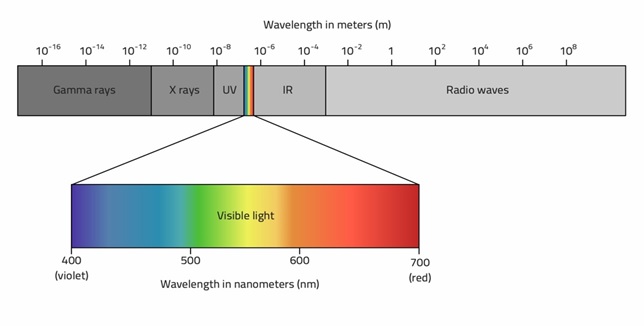
The electromagnetic spectrum ranges from the shorter wavelengths (including gamma and x-rays) to the longer wavelengths (including microwaves and broadcast radio waves). There are several regions of the electromagnetic spectrum which are useful for remote sensing.

Following are the regions of electromagnetic spectrum mostly used in remote sensing
- the ultraviolet or UV
- visible spectrum
- infrared (IR) region
- microwave region
Generalized process of Remote Sensing
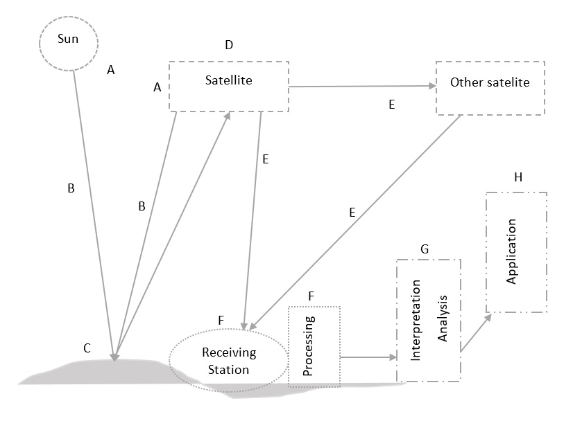
- Energy Source (A):
A source of energy which illuminates or provides electromagnetic radiation to the target of interest. This may be the sun or the source borne by the platforms. - Radiation and the Atmosphere (B):
During transmission of radiation from source to target (ground) it will be intervened by the atmosphere it passes through. This interaction may take place again after energy is reflected or scattered back from the target for second time. - Interaction with the Target (C):
The target can be different surface covers of the earth ground the interaction of incoming radiation can be absorption, reflectance, and transmission. These targets can emit their own energy as well. - Recording by Sensor (D):
The sensors attached to the platform (like satellites, UAVs) for capturing and recording the energy that come there. The incoming energy can be reflected, scattered, or emitted by targets. - Transmission (E):
The recording of the sensor is transmitted to the ground station either directly or through another nearby support satellite. - Reception, and Processing (F):
The data received undergo preprocessing and generate products which can be used by analysts. The preprocessed data can be distributed as photographs or digital products. - Interpretation and Analysis (G):
The processed image is interpreted, visually and/or digitally to extract information about the target. - Application (H):
Dissemination and use of the information extracted from the imagery about the target to solve a particular problem.
Types of Remote Sensing
There are two types of remote sensing technology based on source of EMR,
- active remote sensing,
An active remote sensing system supplies its own source of energy to illuminate the objects and measures the reflected energy returned to the system (similar to photography in night with flash).Active sensors emit energy in order to scan objects and areas whereupon a sensor then detects and measures the radiation that is reflected or back-scattered from the target. RADAR and LiDAR are examples of active remote sensing. - passive remote sensing
In passive remote sensing system, the naturally radiated or reflected energy from the earth’s surface features is measured by the sensors operating in different selected spectral bands on board the air-borne/space-borne platforms (similar to photography in daytime without flash). Examples of passive remote sensors include film photography, infrared, charge-coupled devices, and radiometers.
Passive sensors gather radiation that is emitted or reflected by the object or surrounding areas. Reflected sunlight is the most common source of radiation measured by passive sensors.
